Overcoming Capability Gaps in the Space Domain
Force Multipliers in Army Combat Aviation Brigades
By MAJ David A. Beaumont
Article published on: October 1, 2024 in the Aviation Digest October-December 2024 Issue
Read Time: < 13 mins
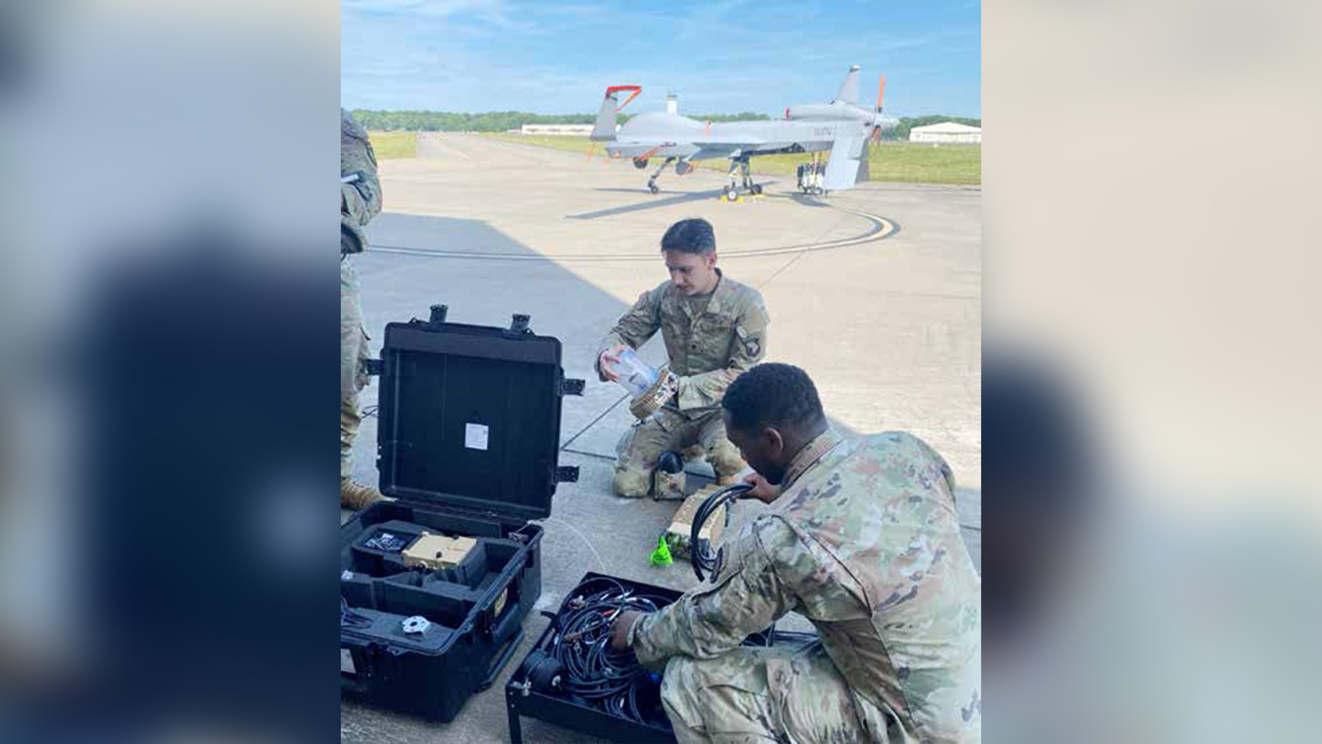
SPC Tyler Marcoux and SPC Dadrian Black (101 CAB S2 35F All-Source Intelligence Analysts) set up the One System
Remote Video Terminal to pull feed from the MC-1C Gray Eagle. U.S. Army photo provided by the author.
In the long haul, our safety as a nation
may depend on our achieving 'Space
Superiority.' Several decades from
now, the important battles may not be
sea battles or air battles, but space battles…" –Gen. Bernard Schreiver, “Space
Superiority” speech at the first Astronautics Symposium, California, 1957.
This quote underscores the critical role
of space-based assets in modern warfare,
emphasizing the urgency and significance of our mission.
Space Enabler (3Y)
Space is a warfighting domain, and the
U.S. military relies heavily on space-based assets to perform its missions in
today’s technologically advanced military. Space is the ultimate high ground;
space-based assets allow U.S. forces to
move with precision, communicate with
forces anywhere on Earth, see the battlefield with clarity, and defend the homeland and forces abroad. Our adversaries
understand our reliance on these assets,
are aware of the U.S. military's use of
space-enabled equipment, and will try
to disrupt those assets. The Army must
ensure enough personnel possess the expertise, training, and experience to meet
current and future national security
space needs. To this end, the U.S. Army
established the Army Space Personnel
Development Office, or ASPDO, which
manages Army personnel attendance at
the foundational professional development space courses.
The U.S. Army, “the largest user of
space-based capabilities” in the military, formalized an Army space cadre
that consists of officers, enlisted, and
civilian personnel (Center for Army
Lessons Learned, 2023, p. viii). The
additional skill identifier (ASI) 3Y,
Space Enabler, identifies personnel
with specialized skills and experience
in space operations. This designation
reflects the increasing recognition of
the critical role that space and spacebased systems play in the future of Army
warfare. To remain competitive in the
evolving space domain, it is essential for
personnel to continually enhance their
technical expertise, engage in advanced
training, and stay updated on emerging technologies and strategies from
strategic levels of thinking down to the
tactical force. Collaboration with other
military branches and civilian agencies
can also foster innovation and ensure
readiness to meet the challenges of
space warfare. The Office of the Chief
of Space and Missile Defense (OCSMD)
aligns training and education requirements to operational needs and career
professional development. It conducts
strategic planning, ensuring cadre billets are identified, created, and tracked
to support space-related missions. The
OCSMD manages the processing and
awarding of the 3Y ASI and Space Badge
progression. The Army does not have an
enlisted, WO, or civilian space career
field. However, OCSMD tracks Army
personnel serving in space operations
billets, and these cadre members can
also attend space training courses that
support their professional development.
Space Enablers in Combat
Aviation Brigades (CAB)
I believe that intelligence and fires professionals in conventional CABs should
be designated as 3Y Space Enablers.
Their role is to enhance operational
capabilities, decision-making, and force
multiplication significantly. These
professionals have access to space-based
intelligence assets, such as satellite
imagery and reconnaissance data, which
provide real-time, high-fidelity information critical for anticipating enemy
movements, identifying threats, and
planning effective operations. Their
designation as 3Y Space Enablers ensures
they receive the necessary training on
space-based programs and capabilities
to leverage assets at echelon, fostering
better coordination with other units and
future-proofing military operations as
warfare extends into the space domain.
Their understanding and use of space-based data will be crucial for providing accurate and timely intelligence,
ultimately enhancing mission success
and resilience.
Combat aviation brigades often lack
organic signals intelligence (SIGINT)
and rarely receive electronic warfare
(EW) personnel, necessitating intelligence analysts (35Fs) to act as information collection managers. The Intelligence Warfighting Function (IWfF)
plays a crucial role in addressing these
shortfalls to fill capability gaps. The
IWfF is responsible for coordinating
and integrating intelligence and EW
into the brigade's operations. Combat aviation brigade military intelligence
(MI) Soldiers use Fusion Analysis and
Development Effort (FADE)/Multi-INT
Spatial-Temporal (MIST) to analyze
SIGINT data, enabling 35Fs to build a
comprehensive enemy air defense picture, which is crucial to aviator survivability (California Analysis Center, Inc.,
2020). Regardless of whether CABs have
EW Soldiers on their modified table of
organization and equipment (MTOE),
35-series personnel should receive
proper training on using Global Navigation Satellite System (GNSS) Operational
Awareness Tool (GOAT) and FADE to
track effects on the operational environment (Space-Based Positioning Navigation & Timing, 2024). These intelligence
programs and software are critical to
providing aviators with relevant and
actionable information, ultimately leading to mission success and a safe return
home (Figure 1).
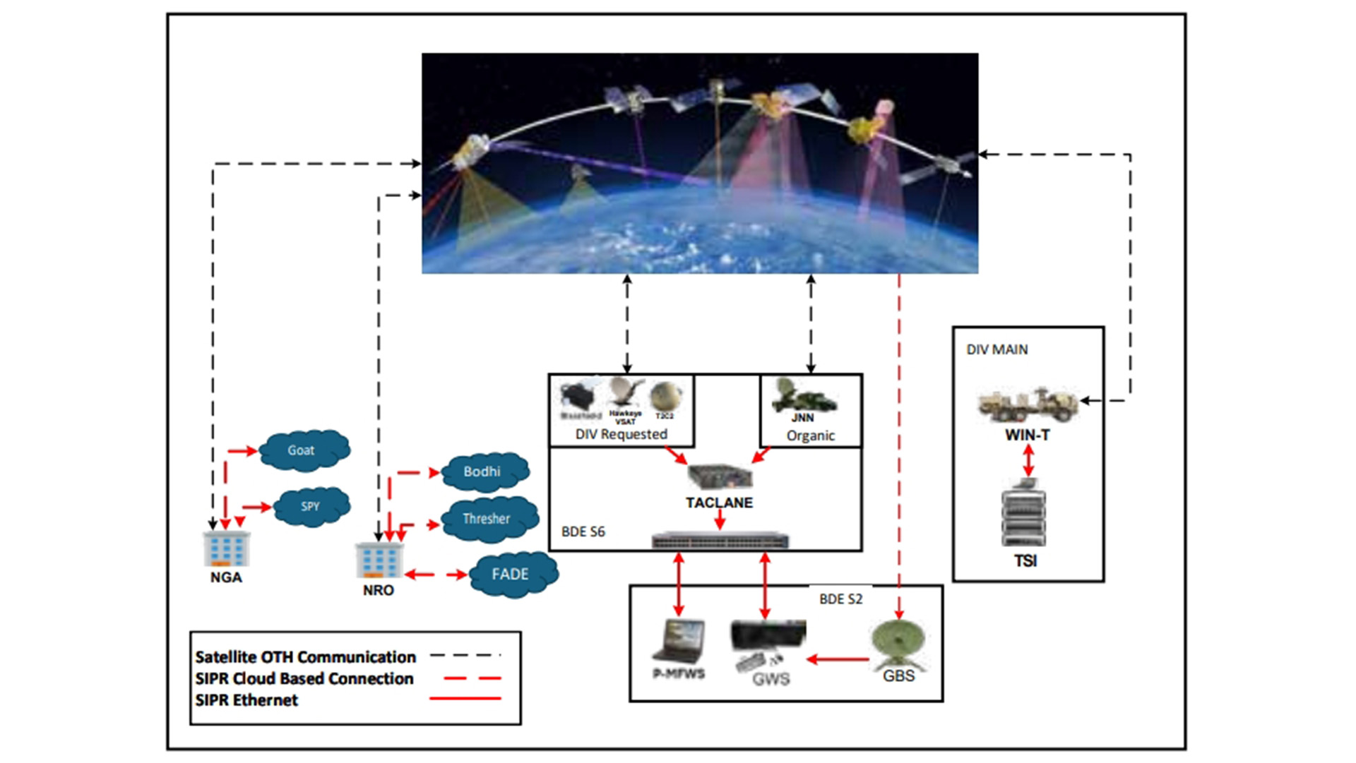
Figure 1. 101 CAB intelligence architecture (Erb, 2024).
Intelligence Architecture
Combat aviation brigade space enablers
are essential to integrate with and
protect air and ground maneuver forces
from hostile threats using space-based
capabilities, facilitating deep sensing
and enabling movement and maneuver.
Space professionals play a crucial role in
enhancing understanding and integrating joint and coalition space capabilities
into operational strategies. The National
Geospatial-Intelligence Agency (NGA)
and the National Reconnaissance Office
(NRO) are key players in this domain,
providing cloud-based solutions critical
to the Department of Defense (DoD)
and the Intelligence Community. These
solutions enable real-time intelligence
gathering and ensure robust situational
awareness and operational planning in
an evolving space domain. For example,
the 101st Airborne Division, Fort Campbell, Kentucky, has effectively employed
Command and Control Fused Information Exchange, or C2FIX, programs
like Starshield, “a militarized version of
SpaceX’s Starlink internet satellites” (Erwin, 2024) for transport and utilized the
Tactical Server Infrastructure at the division level through a flat domain to enhance communication and operational
effectiveness on today’s battlefield. Command and Control Fused Information
Exchange takes the entirety of the network portfolio and condenses it to the
basics of what a maneuver commander
needs to improve decision-making and
facilitate seamless communication and
collaboration among units during operations. A Tactical Server Infrastructure
refers to a network of servers and associated hardware deployed in a military
or operational environment, designed
to operate in challenging conditions,
providing reliable access to information,
applications, and services for tactical
units. Additionally, it houses the local SharePoint, Command Post Computing
Environment, and Data Distribution
Service. At present, the DoD “currently
buys Starlink’s commercial internet
service but in the future it also plans to
acquire more than 100 ‘Starshield’ satellites that would be government-owned”
(Erwin, 2024).
All-Source Intelligence
Officer Justification
All-Source Intelligence Officers (35A)
utilize space-based intelligence, surveillance, and reconnaissance to enable
the core MI competency of Intelligence
Preparation of the Operational Environment (IPOE). Combat aviation brigade
MI officers work closely with space-based intelligence assets such as FADE/
MIST, NRO overhead systems (NOS),
formerly known as national technical
means imagery, and the Global Broadcast System (GBS). These systems and
other SIGINT and geospatial intelligence (GEOINT) platforms are essential
for producing robust IPOE products.
Providing the best intelligence possible
increases efficiency and survivability
for aviators, aircraft, and supporting
Soldiers. Aviators rely on terrestrial and
space weather reports from the S2 officer
(intelligence operations and security)
during operations to anticipate global
positioning system and satellite communications (SATCOM) effects. The CAB
operates the MQ-1C Gray Eagle unmanned aircraft system, providing the
entire division with an organic ground
movement target indicator capability. Although the MTOE authorizes an
information collection manager, MI
officers often assume this role at their
respective echelons, using various space-based assets to inform commanders
and pilots. Brigade S2 officers will also
manage, train, and employ geospatial
imagery analysts (35G) and 12Y sections.
All-Source Intelligence
Analyst Justification
All-Source Intelligence Analysts (35F)
provide weekly global graphic intelligence
summaries In the absence of SIGINT/EW
personnel, 35Fs analyze enemy-integrated
air defense systems using FADE/MIST, maintain the area of operations awareness with Bodhi,1 assess electromagnetic
interference effects on aircraft with GOAT,
and establish air orders of battle with the
data fusion tool, Thresher. Given the CAB’s
need for organic collection assets, 35Fs
must request support from higher echelons
to answer the commander's priority intelligence requirements. Collection can be
obtained using space-based capabilities,
such as NOS imagery and coordination
with echelon collectors. Bodhi, FADE, and
Thresher—all programs of record throughout the DoD’s Intelligence Community—
are critical for building situational awareness and enabling collaboration.
All-Source Intelligence
Technician Justification
The All-Source Intelligence Technician
(350F) is the senior intelligence analyst and
subject matter expert (SME) on all intelligence disciplines and programs. They are
responsible for intelligence analysis and
synchronization across multiple echelons.
The 350Fs integrate information from
all sources, including the CAB's organic
GEOINT cell and analyst cell, into finished
analytical products for the brigade. As
experts in intelligence systems integration,
they fuse multiple intelligence disciplines
across all domains and are expected to
be SMEs on space-based programs. They
train, coach, mentor, and execute information collection with 35As, 35Fs, 35Gs, and
12Ys using tools identified previously.
Geospatial Intelligence
Imagery Analyst Justification
Geospatial Intelligence Imagery
Analysts (35G) play a critical role in
visualizing the operational environment by delivering a range of essential
products, including infrastructure
imagery, tactical equipment identification, overhead persistent infrared
(OPIR) data, and helicopter landing zone (HLZ) information. These
products are generated through space
operational software and systems
used throughout the DoD Intelligence
Community, such as iSpy (web-based,
image-viewing application), the Geospatial Intelligence Search and Retrieval Program (GSR), Map of the World,
and Web-based Information Dominant
Warfare (WIDOW). The GBS antenna
is instrumental in receiving data from
these systems, which is then processed
and disseminated to lower echelons.
iSpy and GSR, maintained by NGA,
are comprehensive repositories of
space-based imagery accessible via
the Non-classified Internet Protocol Router Network, Secure Internet
Protocol Router Network, and Joint
Worldwide Intelligence Communications System networks. Similarly, Map
of the World offers a broad collection
of GEOINT data, including space-based imagery, terrain data, and maps.
Web-based Information Dominant
Warfare is utilized to analyze OPIR
data, with the GBS antenna playing a
critical role in supporting high-volume
data operations.
Geospatial Engineer
Justification
Geospatial Engineers (12Y) are pivotal in
enhancing situational awareness and operational planning by utilizing satellite
imagery and elevation data to provide
commanders with precise terrain analysis. They leverage data such as Digital
Terrain Elevation Data and commercial
satellite imagery to produce critical
products for both wartime and peacetime operations. These products include
detailed HLZs, 3D fly-throughs, line-of-sight analyses, and change detection
reports. GlobalVO™ (Global Vertical Obstruction Data), a new program incorporating satellite imagery and artificial
intelligence, significantly advances these
capabilities by rapidly identifying patterns associated with vertical obstacles
and annotating them across large areas (Foundation Stack AI, 2024). This tool
allows for more efficient and comprehensive terrain analysis, crucial for planning
and executing operations. 12Ys utilize
these data to recommend optimal routes
and HLZs based on the terrain’s slope
and other features, which is essential for
rotary-wing and ground vehicle operations. By integrating their analyses with
the 35Fs, 12Ys can illustrate how terrain
affects troop movement and operational
effectiveness for the opposing force.
Furthermore, 3D fly-throughs offer a
digital preview of the area of operations
before physical deployment, enhancing
mission planning. Line-of-sight analysis, using digital surface models (3D
representation of Earth’s surface) and
elevation data, helps determine visibility
constraints within the environment. At
the same time, change detection provides insights into temporal variations,
which can be invaluable for post-disaster
humanitarian operations.
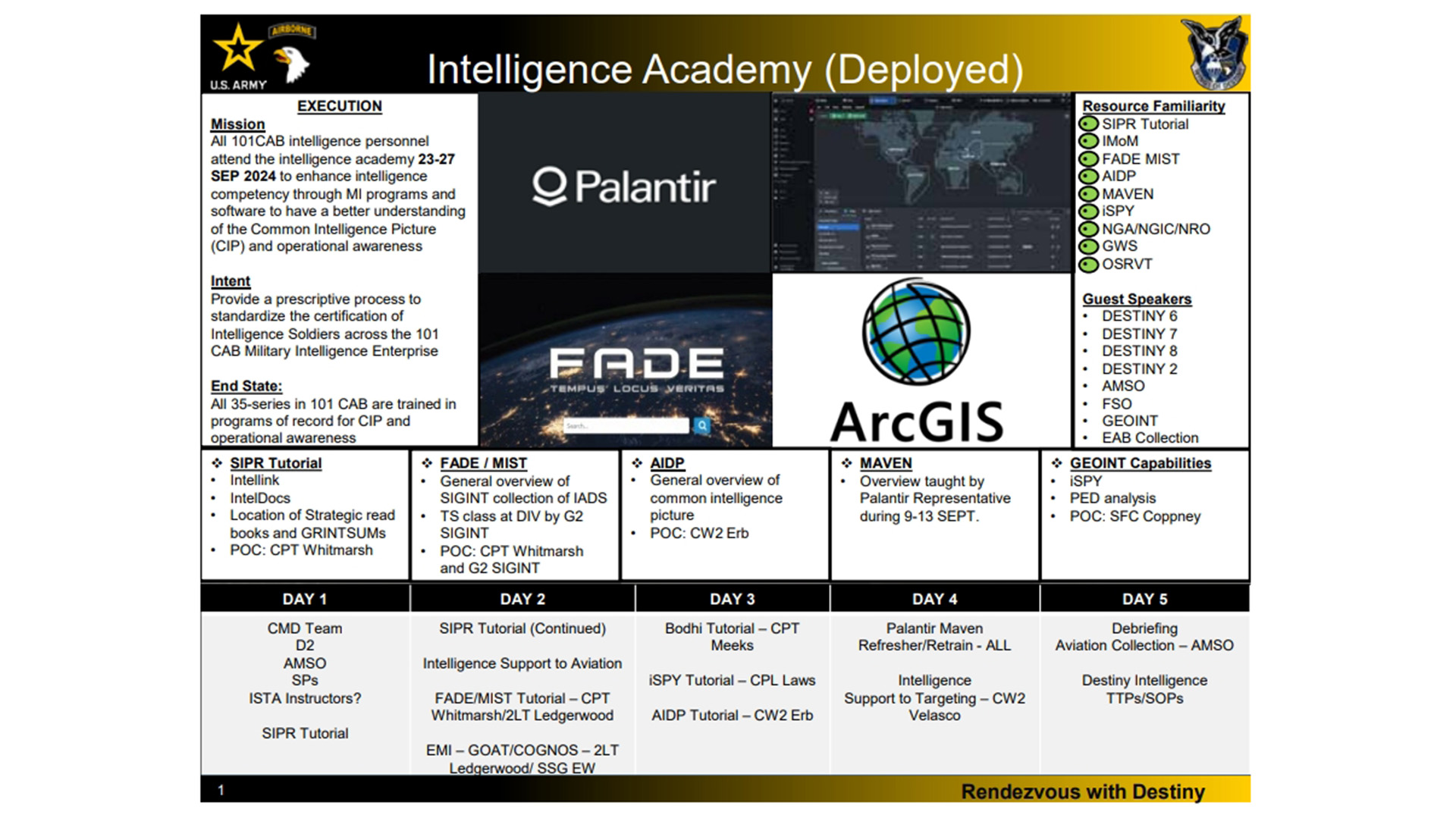
Figure 2. 101 CAB intelligence academy (Beaumont, 2024).
Targeting Officer and Fire
Support Officer Justification
The CAB is authorized one Targeting Officer (131A) who plays a pivotal
role in space operations. They conduct
vital targeting analysis of space-based
assets such as space stations, satellites, and enemy space systems—a
responsibility that underscores the
importance of their role. They are also
instrumental in information collection while identifying enemy space-based communication platforms and
other potential threats in space. The
131A's ability to identify, coordinate,
engage, and collect battle damage assessment of enemy space capabilities
is unmatched within the CAB, further
highlighting their unique contribution. The role of the 131A in space operations is crucial for protecting and
enhancing the effectiveness of space-based assets, a fact that should not be
underestimated. The nomination of
the Brigade Fire Support Officer (13A)
and Brigade Assistant Fire Support
Officer (13A), as a point of redundancy within the Brigade Fire Support
Element, would enable a seamless integration of intelligence collection in
space-based operations with the Fires
Enterprise in the CAB. This is a testament to the Targeting Officer's strategic thinking and planning. Fire Support Officers work extensively within
the targeting process at brigade and
higher echelons and work with the MI
community to conduct space-based
targeting analysis and identification
of space-based enemy assets. This aids
capabilities to use national technical space-based means to detect and
target adversary terrestrial capabilities, further underlining the Targeting
Officer's comprehensive role.
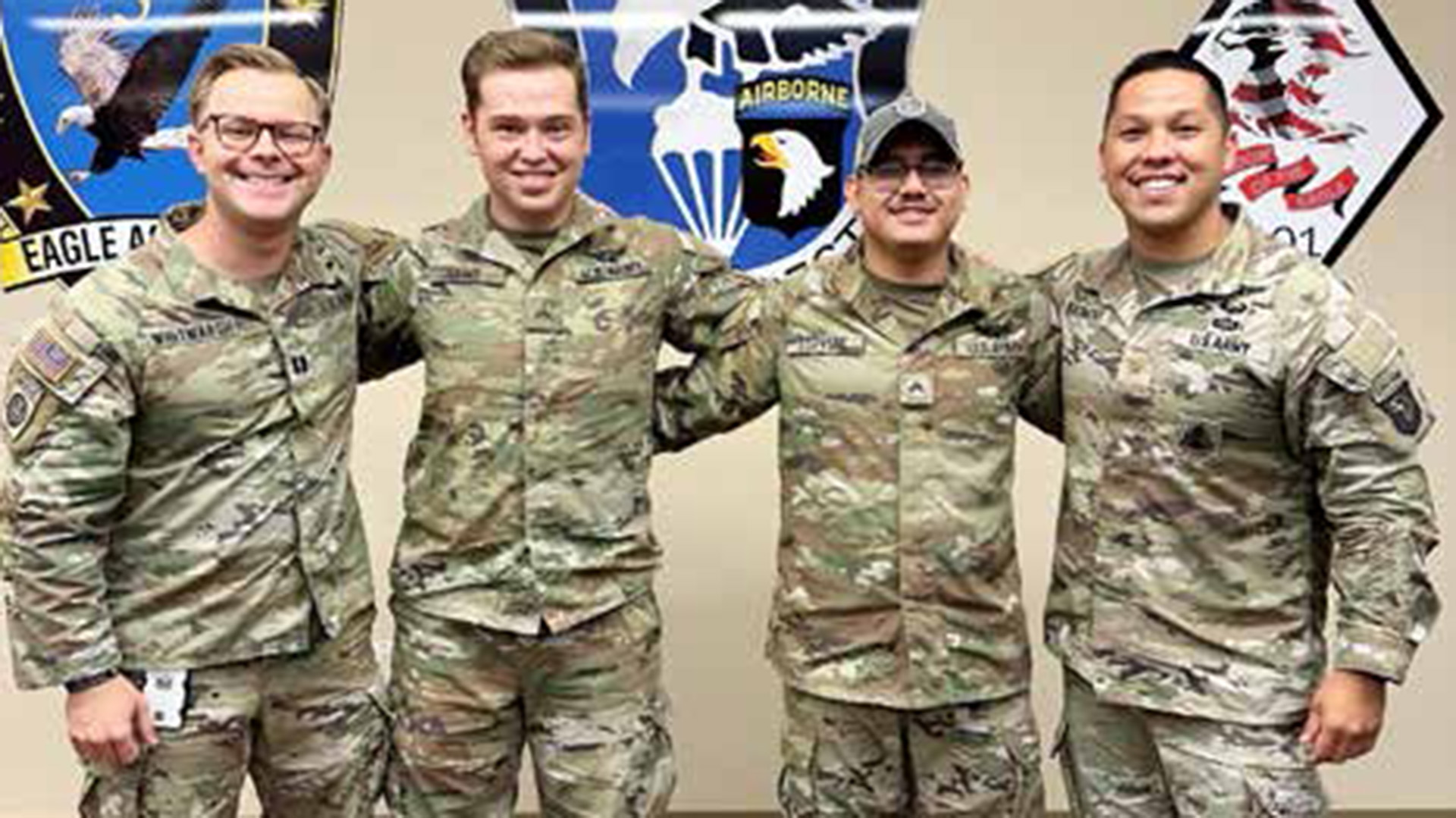
From Left to Right: CPT Jeffrey Whitmarsh (101 CAB AS2), CPL Joshua Laws and CPL Donovan Espitia (101 CAB 35G
Geospatial Intelligence Imagery Analysts), and MAJ David Beaumont (101 CAB S2), were awarded the Army Basic
Space Operations Badge. U.S. Army photo provided by the author.
Conclusion
Receiving space training is invaluable for enabling CABs to fully utilize
space-based intelligence, surveillance,
and reconnaissance capabilities, which
are critical for modern warfare in all
domains (Figure 2). Space training prepares Intelligence and Fires professionals to anticipate and mitigate the effects
of space weather on GPS and SATCOM,
which is crucial for mission planning
and execution. Despite the absence of
organic SIGINT and EW personnel and equipment, integrating advanced intelligence systems and the expertise of the
Intelligence and Fires WfF are essential
for CABs. These roles and capabilities
ensure CABs can leverage space-based
and other intelligence assets to create a
comprehensive intelligence and operational picture, enhancing situational
awareness, operational efficiency, and
the survivability of aviators and support personnel. By utilizing tools such
as FADE/MIST, Bodhi, GOAT, and
Thresher, Intelligence and Fires professionals within CABs can provide
actionable intelligence, mitigate risks,
and support mission success.
The author wishes to thank the following Army Intelligence Officers for
their contributions to this article: CPT
Jeffrey Whitmarsh, CW2 Thomas Erb,
1LT Chase Ledgerwood, SFC Phillip
Coppney, SGT Frank Norris, and CPL
Joshua Laws
Notes
1. “Bodhi is an application that the National Reconnaissance Office developed for visualization, collaboration, and presentation” (Fanitzi et al., n.d.)
References
Beaumont, D.A. (2024). 101 CAB intelligence academy (Figure 2).
California Analysis Center, Inc. (2020). Multi-INT Spatial Temporal (MIST) toolsuite. https://www.caci.com/sites/default/files/2020-02/F367_2002_MIST.pdf
Center for Army Lessons Learned. (2018, June). Operating in a denied, degraded, and disrupted space operational environment (Handbook No. 18-28).
https://api.army.mil/e2/c/downloads/2023/01/19/7f7281ee/18-28-operating-in-a-denied-degraded-and-disrupted-space-operational-environment-handbook-jun-18-public.pdf
Erb, T.C. (2024). 101 CAB intelligence architecture (Figure 1).
Erwin, S. (2024, June 11). Pentagon embracing Space X’s Starshield for future military satcom. SpaceNews.
https://spacenews.com/pentagon-embracing-spacexs-starshield-for-future-military-satcom/
Fanitzi, C., Brady, M., & Wadas, B. (n.d.) Operationalizing the military intelligence brigade–theater operations battalion. Military Intelligence.
https://mipb.army.mil/documents/12618257/15543935/Operationalizing+MIB-T+Ops+BN.pdf/5280d4bd-6ea5-4493-b374-c4188bff5e9e
Foundation Stack AI. (2024). Find more VO features on the fly. https://www.foundationstack.com/globalvo
Space-Based Positioning Navigation & Timing. (2024, January 5). National Space-Based Positioning, Navigation, and Timing (PNT) Executive Steering Group
(ESG) responses to PNT advisory board recommendations. https://www.gps.gov/governance/advisory/recommendations/2024-01-ESG-response-to-PNTAB.pdf#:~:text=DOD%20and%20DHS%20to%20implement%20the%20use%20of%20the%20Naval
U.S. Government Accountability Office. (2021, September). Missile warning satellites. Comprehensive cost and schedule information would enhance Congressional oversight.
https://www.gao.gov/assets/gao-21-105249.pdf
Author
MAJ David Beaumont is the Brigade S2 in
101st CAB. His previous experience includes
Resident Command and General Staff College;
Commander, Company A, 304th MI Battalion; MI
Captains Career Course Small Group Leader and
Instructor; Battalion S2 for 1st Battalion, 27th
Infantry Regiment (WOLFHOUNDS); MI Company
Commander for 2D Infantry Brigade Combat
Team, 25th Infantry Division; Battalion S2 for the
1st Battalion, 94th Field Artillery Regiment (High
Mobility Artillery Rocket System), 17th Field
Artillery Brigade.